Week 20 - They Like to Move it, Move it!
- iainmacneil
- Apr 19, 2022
- 6 min read

The helpful Madagascan currents - was that what the Lemurs were singing about?
We have just had a couple of the nicest days of the trip so far, across Easter Sunday/Easter Monday, with hardly a cloud in the sky. However, we are due to arrive in Durban on Friday, where they are still dealing with the disastrous intense rain and flooding that caused at least 443 deaths last week (with that number still rising)
On Mon 11 April, extreme rain associated with Sub-Tropical Storm Issa, which had formed off the South African coast, brought torrential rain and some areas received as much as 30 cm (12”) of rain or more in a 24 hour period.
The rains flooded roads, stressed dams and brought walls of mud and water down on the city of Durban. Homes and buildings collapsed and the the floods caused substantial damage to the port of Durban, knocking over and floating towers of 40 foot shipping containers onto an adjacent highway.
Port operations at Durban were suspended on the evening of Mon 11 April until Wed 13 Durban is the largest shipping terminal in Africa, handling 60% of all container traffic for South Africa and metals such as copper. Fuel rationing is currently in place along with a number of other measures in Durban, until the situation stabilises.
Sat 16th April (Day 136)
We made landfall to the SE of Mauritius in the early hours of Saturday morning, but there was a sense of déjà vu when Mauritius Coastguard called us up on the VHF to tell us to keep 12 miles off the coast – even though our destination is Port Louis.
This sort of routeing measure is easily accommodated when you know about them at the planning stage, but it's not so great when you are already 9 miles from the coast.
We double-checked the Admiralty List of Radio Signals and the Sailing Directions for Mauritius and there was no mention of a requirement to keep 12 miles off and nothing was noted on the chart or had been advised by our local agent.
As we discussed this and muttered and grumbled on the bridge… Dan said “…wasn’t it Mauritius, where the bulk carrier ran aground a couple of years ago?”.
Aaaaaah, yes! The MV Wakashio was a of 300 metres bulk carrier weighing 203,000 tonnes DWT, that was built in 2007 and operated by a crew of 20. It left China on 04 July 2020 bound for Brazil and grounded on a coral reef on the SE of Mauritius on 25 July 2020. According to investigators, the crew had been celebrating the birthday of a sailor on board the ship at the time of the grounding and had sailed near shore for a phone signal. Most of the bunker fuel was pumped out before the ship broke in half and 'only' 1,000 tonnes of oil spilled in to the sea. After breaking in half, the bow section was towed out to sea, in August 2021, and scuttled. Sadly a tugboat sank while working on the stern section with the loss of 3 persons.
In the light of this incident it was fully understandable as to why the Mauritius Coastguard was so jumpy and calling up every ship that passes


We carried on to Port Louis and arrived a little later due to our 12 mile limit detour, anchoring at 08:06 Hrs. Shortly after anchoring, a Doctor boarded to conduct PCR tests of all the crew and then waited 8hrs at anchor for the results to come through.
The time was put to good use, with Luke doing an oil change of the main engine (370 Litres) and changing the main engine fuel filters.
There was a lot of activity in the many anchorages off Port Louis, with a number of large tankers and gas tankers at anchor taking on bunkers. Port Louis is working hard to capitalise on its location as a port with a lot of non-congested anchorage areas and immediate proximity to the shipping lanes for ships coming from/to Atlantic ports to/from the Far East.

We berthed opposite the town at 16:30 Hrs and, in our quickest port turnaround yet, departed 3 Hrs later after loading 23,500 litres of fuel, receiving stores and welcoming back Paul and Carlos and saying farewell to Luke and Pete.
Carlos got the chance to thank Pete, who had stepped in temporarily as Junior Watchkeeper. Carlos needed to go to Lanzarote to conclude his Spanish Citizenship (exciting!) and was delighted to be able to show Pete his shiny new passport.
Thanks Pete!
*************************Boat Nerd Alert - You are Warned!************************
The Skipper's 3 Key items of equipment onboard
Having been onboard Astra for about 18 months (really? it seems only days .........Ed) during the trials and preparations for the circumnavigation as well as the trip itself, the three items our I would not be without are:
1) VSAT (Already covered fairly extensively and gets a mention again this week)
2) Stabilisers
3) Wave Analyser
You will have spotted the stabilisers and wave analyser in previous weekly updates, but I wanted to give a quick overview of these two vital pieces of equipment that have served us well in the most challenging of conditions.
Stabilisers
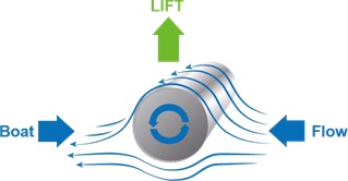


Our ‘MagnusMaster' stabilisers were developed by Dynamic Marine Systems in the Netherlands. The system combines technology and stability algorithms to provide phenomenal roll damping from as low as 3 knots and up to 12 knots of boat speed. MagnusMaster uses a 'universal law of nature', the Magnus effect, which was discovered and documented by Heinrich Gustav Magnus. The law states:
“If you pass a rapidly rotating smooth object through a fluid medium (whether that medium be a liquid or air) a resulting force is created on the object causing its path to be deflected. The direction of the force will depend on the relative direction of rotation of the object and other factors”.
A simplified explanation is that when fitted horizontally for the stabilisation of a vessel, the movement of the hull through the water produces flow over the MagnusMaster rotor(s), which in turn produces either an upward or downward force depending on the direction of rotation of the rotor. This will counter the rolling action.
Wave Analyser
The FURUNO Wave Analyser WV-100 uses the performance capabilities of FURUNO’s FAR-2xx8 and FAR-3xx0 Radars to provides real-time monitoring and analysis of wave echoes at sea (day or night). It has been a key decision support tool in heavy weather.
It is a sophisticated piece of software that uses the radar data, but it in no way affects radar performance.

Wave spectrum display - The Color of the wave spectrum indicates the relative intensity of the wave spectrum display.
Radar echo display - The absolute intensity of the radar reflection from the wave increases in order of dark blue, light

blue, light green, dark green, orange, yellow, red.
Significant wave height - The significant wave height is a statistical value obtained by averaging the height of the one-third highest waves when observing the specified area.
[1st Wave] [2nd Wave] - Among the observed waves, the two most outstanding waves are selected and assigned as [1st Wave] and [2nd Wave] for reference. There is no distinction made between wind waves and swells for this selection.
Radar information (Display order) - Antenna ID, Band width, Transceiver type, Pulse width and Display range.
Technical Spec: Courtesy FURUNO.
*************************End of Boat Nerd Alert - **********************************
Sun 17/04 (Day 137)


Today started with an Easter egg hunt, as Dan, Carlos and Pete had all picked up Easter eggs as a surprise for those onboard.......at least we think thats how they got there.....
Sunday evening we held a feast to celebrate Carlos’s Spanish citizenship, the cause of his brief return to Lanzarote earlier in the month.
We are grateful to our legal firm, Fernandez & Wenzel in Arrecife, for taking some of the stress out of the process.
Mon 18/04 (Day 138)
We are fully expecting to achieve very good speeds as we pick up the body of the Mozambique Current while making our run in from Madagascar to the South African coast. At 12:00 today we recorded our fastest day’s run to date, with a distance travelled of 264 miles = 11.00 Knots.
Tue 19/04 (Day 139)

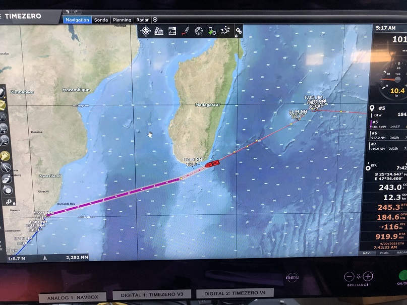
We will pass south of Madagascar in the evening and our speed will likely increase to 12.0 knots as we start to get into the body of the current to the SE of Madagascar. Fingers crossed to see if we can break a distance of 300 miles in a 24 hour period over the next couple of days!
ETAs
Durban Fri 22 April
Cape of Good Hope Mon 25 April
Saint Helena Mon 02 May
Lanzarote Sun 15 May


Hi Mark,
thanks for your comments - love the story about the baseball "rounding third and heading for home"…
Now that I am vicariously becoming a veteran of the sea, I understand that anything can happen; however, it has to be comforting to have had at least one week without drama. Thanks also for the notes about the stabilizer and wave analyzer (sounds a bit like the Doppler technology used for weather forecasts). You've mentioned both often and the explanations are very helpful. I'm guessing a less capable captain would not have chosen/or known to include such valuable assets and may have paid mightily for their absence. I assume no one on board a baseball fan, but to score a run in baseball, a runner has to make his way around a diamond shaped field going 90' from…